Optimization of the use of the River-Retention Pond System as an adaptive response to the Climate Change impact on water supply in rural Districts in the Caribbean.
Adrian Lutchman, F. Addo-Yobo*,
The Department of Process Engineering, The University of Trinidad and Tobago, Point LIsas, Couva, Trinidad and Tobago.
* Corresponding Author
Abstract.
Many Eastern Caribbean Countries suffer variations in rainfall patterns, with attendant periods of drought and excessive downpour and flooding partly due to the adverse impacts of climate change on local weather patterns. As a result it has become necessary to modify or create additional infrastructure to achieve resilient supply to meet the needs of the population. However, the conundrum here: is that the longer term impact of climate change is unpredictable therefore it is inadvisable to invest heavily in infrastructure which might become redundant or even prejudice future adaptive responses. It is for this reason that the OECD advocates the exploitation of existing resources or natural pre-existing facilities and adapting them to meet the requirements (New Zealand, OECD report).
In Caribbean as in Canada, a promising adaptive response is to harvest surface water in rivers and treat it in modular water treatment plants located close the districts for which there is chronic periodic water shortage. These areas also suffer inundation and flooding in many countries in the Eastern Caribbean area. Our previous work has used the PRMS (Precipitation Runoff Modelling system) within GSFLOW software to model the hydrology of watersheds and asses and predict water availability in the rivers (Lutchman, Addo-Yobo 2024) based on historic and future climate data, and existing surface cover of the land. The strategy has been based on using the river-retention pond system to provide water to a potable treatment plant as well as attenuating the risk of flooding downstream. This is less expensive for augmenting existing infrastructure to improve water supply resilience compared to building dams or artificial ponds. The present work uses chemical engineering techniques to determine the pond filling schedule that minimizes the risk of flooding integrated over time, subject to the constraint of ensuring the plant has adequate water for potable treatment.
This presentation exploits GSFLOW, an open source software, for mechanistic modelling of the hydrology of the Vega Oropouche watershed as a tool for managing the provision of surface water for potable treatment and reducing the risk of flooding based of a simplified objective function subject to various constraints. The Vega-Oropuche watershed has only one major river, an aquifer and several ponds which have been created by sand mining decades ago which can now be opportunistically harnessed for storage of water from the river for the above purpose and which in future can also be used for water retention to mitigate flooding.
Methods
The model requires time series input of precipitation and temperature, which are influenced by climate change. Global Circulation Models (GCM) and Regional Circulation Models (RCM) have been calibrated alongside weather generating algorithms to predict historic data and future data over a 30 year horizon (2024-2055) (Bachoo, Lutchman and Addo-Yobo). Whereas prediction of the impact of climate data on hydrology is essentially stochastic, this work employs deterministic methods in predicting the rainfall-runoff into the rivers. The variance of the error distributions has been approximated by linearized precipitation-runoff approximations (Farmer, William H., and Richard M., Vogel, (2016)).
Results
Table 1: Bathymetric and Lidar Studies of the Ponds
Sites Surface Area (m2) Average Depth(m) Volume(Imperial Mgal)
Vega de Oropouche Pond 100,333 7 183
Tapana Pond 99,200 4.5 99
New Pond 1 68,500 WIP WIP
New Pond 2 132,000 WIP WIP
New Pond 3 120,110 4 105.7
Figure 1 shows the characteristic curves, depicting the evolution of the volume of water retained at the base case Pond, for the different filling regimes and, the capacities of the pristine and the dredged pond (shown respectively as solid and broken horizontal lines). The rates at which water has to be excluded from the pond, when it is full by shutting the valves to the pond at the weir on specific days are shown in red. The blue curve demonstrates that the dredged retention pond would meet the requirement of the pond to provide 4 million gallons per day of water for treatment and reserve space for excess flood water from the River to be held. For a few-days between 580th and 680th days and also on days 1074, 1357 and 1374, the valve at the weir would have to be closed to prevent the pond from filling beyond capacity. This represents less than 15% of water which could have been diverted to the pond, were it larger. The policy is such that 25% of the river flow is diverted to the pond area at low flow rates and 80% percent diverted at high flow rates.
Figure. 1: Evolution of volume of water retained at the RSSP Pond over a three years and ten-months.
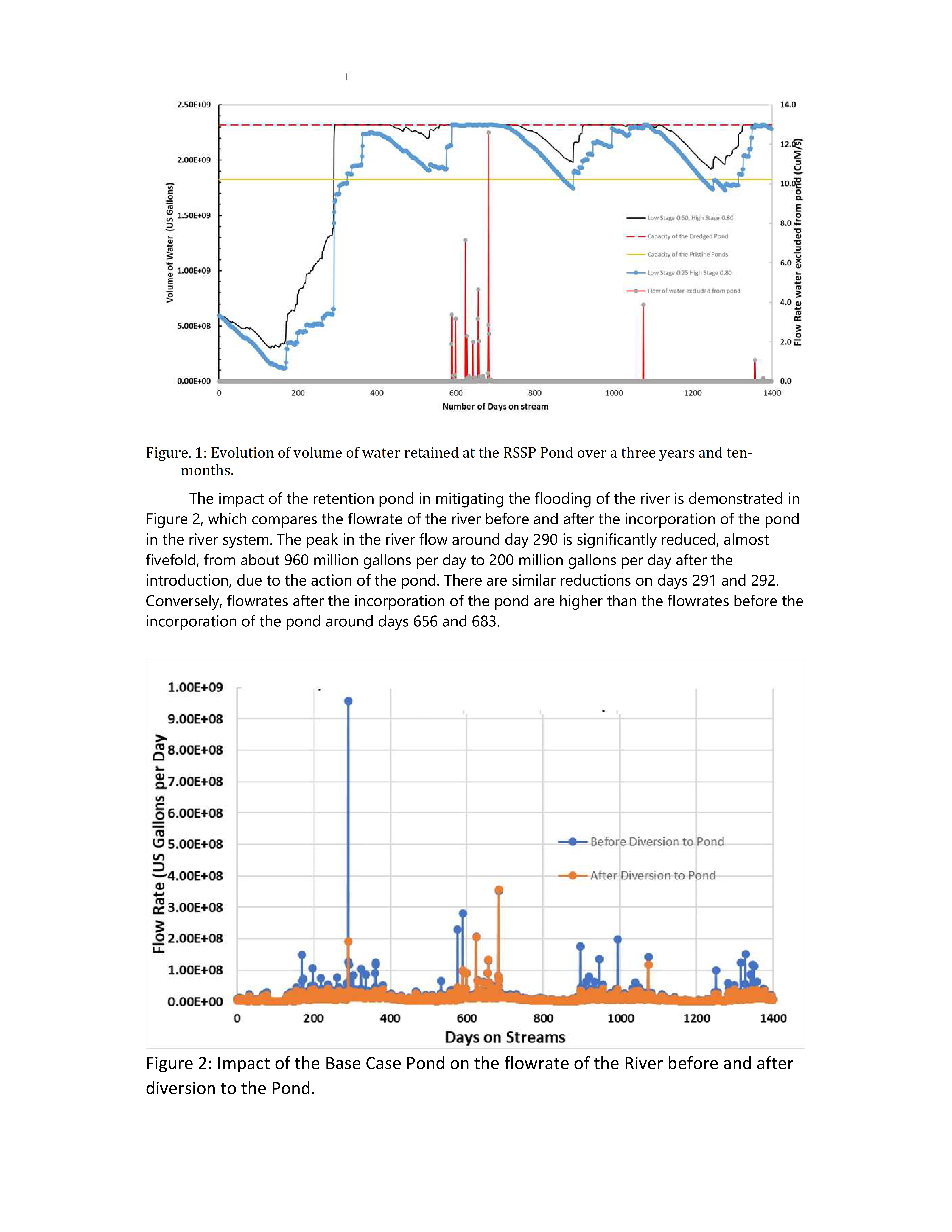
The impact of the retention pond in mitigating the flooding of the river is demonstrated in Figure 2, which compares the flowrate of the river before and after the incorporation of the pond in the river system. The peak in the river flow around day 290 is significantly reduced, almost fivefold, from about 960 million gallons per day to 200 million gallons per day after the introduction, due to the action of the pond. There are similar reductions on days 291 and 292. Conversely, flowrates after the incorporation of the pond are higher than the flowrates before the incorporation of the pond around days 656 and 683.
Figure 2: Impact of the Base Case Pond on the flowrate of the River before and after diversion to the Pond.
Conclusion and Future work
Our work has shown that modelling of the characteristics of watersheds, the recharge from neighbouring rivers and ponds in locality of the Vega-Oropouche River in Trinidad and Tobago, is useful for assessing the feasibility of water projects, and their resilience to climate change.
The work has demonstrated conclusively that the inclusion of one retention pond of capacity 2.4 billion gallons (the base case) significantly impacts the daily flood risk and the integrated flood risk over a period of three years, when compared to the situation when the pond is not used. Future iteration will consider the deployment of the other ponds of with varying capacities in the River-Retention Pond scheme.
References
Farmer, William H., and Richard M., Vogel, (2016), “On the deterministic and stochastic use of hydrologic models”, Water Resources. Res., 52, 5619–5633, 2016, doi:10.1002/2016WR019129.
UNEP (2000), “Dams and Development: A New Framework for Decision-Making”. The Report of the World Commission on Dams, Earthscan, London
World Economic Forum, http://www3.weforum.org/docs/WEF_Global_Risks_2015_Report15.pdf
Adrian Lutchman, Festus Addo-Yobo, Amarnath Chinchamee, Shalini Ramsaran Baksh, and Daniel Sammy “Hydrological Modelling of Ravine Sable Watershed for Evaluation of Surface Water Supply for Treatment and Flood Mitigation
Adrian Lutchman and Festus Addo-Yobo, “Sourcing surface water from the Vega-Oropouche watershed for potable water treatment; an adaptive response to climate change in an eastern Caribbean Country”, International Conference on Water Management and Modelling, February 2024, Ontario, Canada.